Jebel Akhdar is located in the Sharqiyah region of Oman, and in Arabic it means "the green mountain." We parked the bus at the base of the mountain and transferred into 4x4s. The falaj at the base of the mountain had been paved, with stone bridges over the falaj. Some local boys were using the falaj as relief from the heat, climbing underneath the bridges and floating down the channels.
We soon understood why the 4x4s were necessary: the mountain road was steep and windy. Our bus would have made it about 10 feet. It took a while to reach the summit, but the view from the top was magnificent.
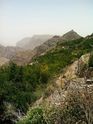
From the overlook, you could see small villages scattered on the terraces below. And the mountain was surprisingly green: the falaj systems keep the terraces blooming with grapes, pomegranates, apples, grass for goats, olive trees, and corn, among other crops.
The stone outcroppings of the overlook also showcased the mountain's geological history: scores of worms, coral, shells and fish were captured in the rock. This area used to be underwater, and we could see the beautiful remnants everywhere.
After walking along the falaj from village to village, we ate lunch and headed over to Wadi Ben Habib, a village abandoned about the time that Sultan Qaboos came into power (1970) and began his modernization regimes. You can explore the village, and get a sense of the structure and architecture of the old style of houses. Wadi Ben Habib looks over a wadi (obviously) where there are other inhabited villages, barely visible in the photo below - they are made from adobe and blend well into the surrounding land.
It was great fun to trek around the mountain all day, climbing on ruins, aflaj, and walls. The weather was warm, but far more temperate than humid sticky Muscat. We got tired out pretty quickly, and after arriving back to the hotel, hit the hay as soon as possible. Now, there is but to take the final exam and buy gifts at Matrah Souq...and then, on Thursday, my time in Oman will come to a close.


